Geolocate

Rajarhat topographic map

Click on the map to display elevation.

About this map

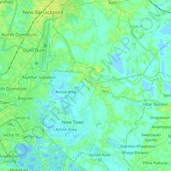
Name: Rajarhat topographic map, elevation, terrain.

Location: Rajarhat, North 24 Parganas, West Bengal, India (22.55607 88.39162 22.68522 88.55577)

Average elevation: 13 ft

Minimum elevation: -10 ft

Maximum elevation: 39 ft

Gear up for your next adventure:

Solar GPS Watches - Advanced multisport watches with built-in topographic maps
Camping Coffee Makers - Enjoy premium coffee at the summit or campsite
🔭Stargazing Telescopes - Perfect for camping in low-light pollution areas shown on maps
🌡️Portable Weather Meter - Track weather conditions on the trail
🗻Climbing Gear Basics - Essential gear for beginner climbers

As an Amazon Associate, this site earns from qualifying purchases at no extra cost to you.