
Village of Trumansburg topographic map
Interactive map
Click on the map to display elevation.
About this map
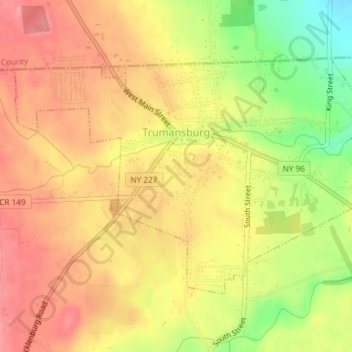
Name: Village of Trumansburg topographic map, elevation, terrain.
Average elevation: 984 ft
Minimum elevation: 810 ft
Maximum elevation: 1,086 ft
Tompkins County trails, hiking, mountain biking, running and outdoor activities
Other topographic maps
Click on a map to view its topography, its elevation and its terrain.
Lafayette Corners
United States > New York > Tompkins County > Town of Groton
Average elevation: 1,371 ft
Terpening Corners
United States > New York > Tompkins County > South Lansing
Average elevation: 945 ft
Caroline Depot
United States > New York > Tompkins County > Town of Caroline
Average elevation: 1,207 ft
East Ithaca
United States > New York > Tompkins County > Ithaca > East Ithaca
Average elevation: 768 ft