Geolocate

Lymore topographic map

Click on the map to display elevation.

About this map

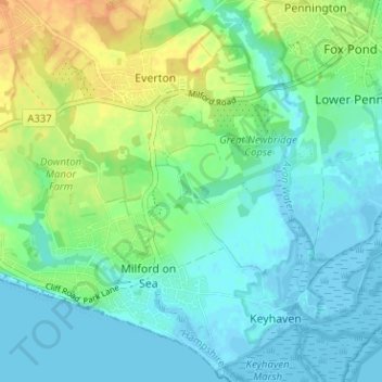
Name: Lymore topographic map, elevation, terrain.

Location: Lymore, Milford-on-Sea, Milford on Sea, New Forest, Hampshire, England, SO41 0TW, United Kingdom (50.71492 -1.60212 50.75492 -1.56212)

Average elevation: 36 ft

Minimum elevation: -16 ft

Maximum elevation: 112 ft

Other topographic maps

Click on a map to view its topography, its elevation and its terrain.

Gear up for your next adventure:

🛶Inflatable Kayak - Portable kayak for rivers, lakes, and expeditions
🪶Compact Camp Shovel - Folding shovel for campsite tasks
🌧️Backpack Rain Cover - Keep gear dry in wet weather
📖Nature Tracking Books - Learn to track wildlife and terrain
🩳Quick‑Dry Hiking Shorts - Comfortable and quick‑dry shorts for summer hiking

As an Amazon Associate, this site earns from qualifying purchases at no extra cost to you.