
Thank you for supporting this site ❤️
Make a donation
Make a donation
Gear up for your next adventure:
As an Amazon Associate, this site earns from qualifying purchases at no extra cost to you.
Palanda topographic map
Click on the map to display elevation.
Thank you for supporting this site ❤️
Make a donation
Make a donation
Gear up for your next adventure:
As an Amazon Associate, this site earns from qualifying purchases at no extra cost to you.
About this map
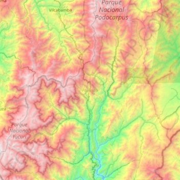
Name: Palanda topographic map, elevation, terrain.
Location: Palanda, Zamora Chinchipe, 190302, Ecuador (-4.81107 -79.39629 -4.22889 -78.82237)
Average elevation: 7,329 ft
Minimum elevation: 2,648 ft
Maximum elevation: 12,641 ft
Thank you for supporting this site ❤️
Make a donation
Make a donation
Gear up for your next adventure:
As an Amazon Associate, this site earns from qualifying purchases at no extra cost to you.
Other topographic maps
Click on a map to view its topography, its elevation and its terrain.
El Panecillo
Ecuador > Zamora Chinchipe > Palanda > El Porvenir del Carmen
Average elevation: 5,397 ft