
Make a donation
Gear up for your next adventure:
As an Amazon Associate, this site earns from qualifying purchases at no extra cost to you.
Star Valley Ranch topographic map
Click on the map to display elevation.
Make a donation
Gear up for your next adventure:
As an Amazon Associate, this site earns from qualifying purchases at no extra cost to you.
About this map
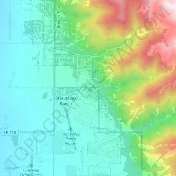
Name: Star Valley Ranch topographic map, elevation, terrain.
Location: Star Valley Ranch, Lincoln County, Wyoming, United States (42.95359 -110.98832 43.01094 -110.93853)
Average elevation: 6,867 ft
Minimum elevation: 5,892 ft
Maximum elevation: 9,596 ft
Lincoln County trails, hiking, mountain biking, running and outdoor activities
Make a donation
Gear up for your next adventure:
As an Amazon Associate, this site earns from qualifying purchases at no extra cost to you.
Other topographic maps
Click on a map to view its topography, its elevation and its terrain.
Make a donation
Gear up for your next adventure:
As an Amazon Associate, this site earns from qualifying purchases at no extra cost to you.