
Make a donation
Gear up for your next adventure:
As an Amazon Associate, this site earns from qualifying purchases at no extra cost to you.
Mambal topographic map
Click on the map to display elevation.
Make a donation
Gear up for your next adventure:
As an Amazon Associate, this site earns from qualifying purchases at no extra cost to you.
About this map
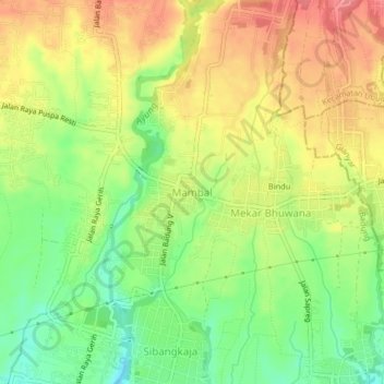
Name: Mambal topographic map, elevation, terrain.
Location: Mambal, Badung, Bali, Lesser Sunda Islands, 80352, Indonesia (-8.56937 115.20195 -8.52937 115.24195)
Average elevation: 433 ft
Minimum elevation: 302 ft
Maximum elevation: 554 ft
Make a donation
Gear up for your next adventure:
As an Amazon Associate, this site earns from qualifying purchases at no extra cost to you.
Other topographic maps
Click on a map to view its topography, its elevation and its terrain.
Make a donation
Gear up for your next adventure:
As an Amazon Associate, this site earns from qualifying purchases at no extra cost to you.
Pecatu
Pecatu is located in South Kuta District of Badung Regency. It is at the western end of the Bukit Peninsula in south Bali, and has a hilly topography with limestone cliffs isolating small, short beaches that have been privately developed. Nusa Dua, on the opposite side of the peninsula, is flat and is a…
Average elevation: 256 ft
Make a donation
Gear up for your next adventure:
As an Amazon Associate, this site earns from qualifying purchases at no extra cost to you.
Make a donation
Gear up for your next adventure:
As an Amazon Associate, this site earns from qualifying purchases at no extra cost to you.
Make a donation
Gear up for your next adventure:
As an Amazon Associate, this site earns from qualifying purchases at no extra cost to you.
Make a donation
Gear up for your next adventure:
As an Amazon Associate, this site earns from qualifying purchases at no extra cost to you.