
Make a donation
Gear up for your next adventure:
As an Amazon Associate, this site earns from qualifying purchases at no extra cost to you.
Spences Bridge topographic map
Click on the map to display elevation.
Make a donation
Gear up for your next adventure:
As an Amazon Associate, this site earns from qualifying purchases at no extra cost to you.
Spences Bridge
Spences Bridge's location is mountainous, with higher elevations part of the Interior Plateau. The east side of the Fraser here is part of the Clear Range, a mountainous southwards extension of the Fraser Plateau located in the angle of the Thompson and Fraser Rivers. Arthur Seat lies in that range on the west side of Spences Bridge, and was named by pioneer John Murray for Arthur's Seat in Edinburgh, Scotland.
Make a donation
Gear up for your next adventure:
As an Amazon Associate, this site earns from qualifying purchases at no extra cost to you.
About this map
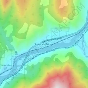
Name: Spences Bridge topographic map, elevation, terrain.
Average elevation: 1,624 ft
Minimum elevation: 699 ft
Maximum elevation: 3,921 ft
Make a donation
Gear up for your next adventure:
As an Amazon Associate, this site earns from qualifying purchases at no extra cost to you.
Other topographic maps
Click on a map to view its topography, its elevation and its terrain.
Blue Earth Lake Provincial Park
Canada > British Columbia > Thompson-Nicola Regional District > Area I (Blue Sky Country)
Average elevation: 5,052 ft