
Make a donation
Gear up for your next adventure:
As an Amazon Associate, this site earns from qualifying purchases at no extra cost to you.
Bowdens topographic map
Click on the map to display elevation.
Make a donation
Gear up for your next adventure:
As an Amazon Associate, this site earns from qualifying purchases at no extra cost to you.
About this map
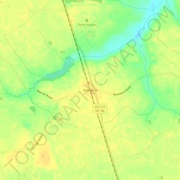
Name: Bowdens topographic map, elevation, terrain.
Location: Bowdens, Duplin County, North Carolina, 28329, United States (35.03711 -78.13555 35.07711 -78.09555)
Average elevation: 151 ft
Minimum elevation: 92 ft
Maximum elevation: 180 ft
Duplin County trails, hiking, mountain biking, running and outdoor activities
Make a donation
Gear up for your next adventure:
As an Amazon Associate, this site earns from qualifying purchases at no extra cost to you.
Other topographic maps
Click on a map to view its topography, its elevation and its terrain.
Beulaville
United States > North Carolina > Duplin County
Beulaville is located on the coastal plain of North Carolina in Duplin County. It is situated at 85 feet (26 m) above sea level, with only minimal changes in topography. Limestone Creek, a small body of water that runs into the Northeast Cape Fear River at Hallsville, borders the western boundary of town.…
Average elevation: 89 ft