
Thank you for supporting this site ❤️
Make a donation
Make a donation
Gear up for your next adventure:
As an Amazon Associate, this site earns from qualifying purchases at no extra cost to you.
Voldöpp topographic map
Click on the map to display elevation.
Thank you for supporting this site ❤️
Make a donation
Make a donation
Gear up for your next adventure:
As an Amazon Associate, this site earns from qualifying purchases at no extra cost to you.
About this map
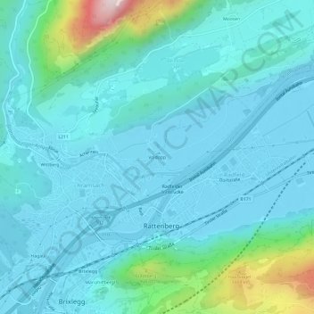
Name: Voldöpp topographic map, elevation, terrain.
Location: Voldöpp, Kramsach, Bezirk Kufstein, Tirol, 6240, Österreich (47.42864 11.87331 47.46864 11.91331)
Average elevation: 2,041 ft
Minimum elevation: 1,667 ft
Maximum elevation: 4,236 ft
Thank you for supporting this site ❤️
Make a donation
Make a donation
Gear up for your next adventure:
As an Amazon Associate, this site earns from qualifying purchases at no extra cost to you.
Other topographic maps
Click on a map to view its topography, its elevation and its terrain.