
Make a donation
Gear up for your next adventure:
As an Amazon Associate, this site earns from qualifying purchases at no extra cost to you.
Albrechtsberg topographic map
Click on the map to display elevation.
Make a donation
Gear up for your next adventure:
As an Amazon Associate, this site earns from qualifying purchases at no extra cost to you.
Albrechtsberg
Rund 1,2 km ostnordöstlich des Gipfels zweigt die Bundesstraße 480 in Richtung Süden von der B 236 ab; von dort haben beide Straßen in Richtung Nordosten bis nach Winterberg einen gemeinsamen Abschnitt und letztere ist abschnittsweise Teil der Ferienstraße Hochsauerland-Höhenstraße. An diesem Abzweig liegt der Wanderparkplatz Albrechtsplatz (729 m), von dem man zum Beispiel auf dem Rothaarsteig, der von Hoheleye zu diesem Parkplatz führt, zum Albrechtsberg laufen kann.
Make a donation
Gear up for your next adventure:
As an Amazon Associate, this site earns from qualifying purchases at no extra cost to you.
About this map
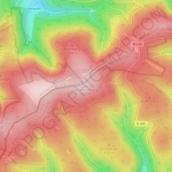
Name: Albrechtsberg topographic map, elevation, terrain.
Average elevation: 2,231 ft
Minimum elevation: 1,644 ft
Maximum elevation: 2,539 ft
Make a donation
Gear up for your next adventure:
As an Amazon Associate, this site earns from qualifying purchases at no extra cost to you.
Other topographic maps
Click on a map to view its topography, its elevation and its terrain.
57319
Deutschland > Nordrhein-Westfalen > Kreis Siegen-Wittgenstein > Bad Berleburg
Average elevation: 1,588 ft