
Make a donation
Gear up for your next adventure:
As an Amazon Associate, this site earns from qualifying purchases at no extra cost to you.
Delmas topographic map
Click on the map to display elevation.
Make a donation
Gear up for your next adventure:
As an Amazon Associate, this site earns from qualifying purchases at no extra cost to you.
About this map
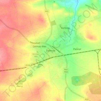
Name: Delmas topographic map, elevation, terrain.
Average elevation: 5,138 ft
Minimum elevation: 4,984 ft
Maximum elevation: 5,256 ft
Make a donation
Gear up for your next adventure:
As an Amazon Associate, this site earns from qualifying purchases at no extra cost to you.
Other topographic maps
Click on a map to view its topography, its elevation and its terrain.
Wilge River
South Africa > Mpumalanga > Nkangala > Victor Khanye Local Municipality
Average elevation: 5,056 ft
Wilge River
South Africa > Mpumalanga > Nkangala > Victor Khanye Local Municipality
Average elevation: 5,020 ft
Victor Khanye Ward 9
South Africa > Mpumalanga > Nkangala > Victor Khanye Local Municipality
Average elevation: 5,007 ft