
Thank you for supporting this site ❤️
Make a donation
Make a donation
Gear up for your next adventure:
As an Amazon Associate, this site earns from qualifying purchases at no extra cost to you.
Segovia topographic map
Click on the map to display elevation.
Thank you for supporting this site ❤️
Make a donation
Make a donation
Gear up for your next adventure:
As an Amazon Associate, this site earns from qualifying purchases at no extra cost to you.
About this map
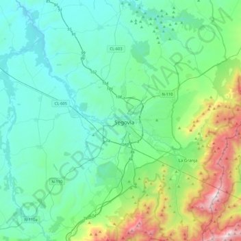
Name: Segovia topographic map, elevation, terrain.
Location: Segovia, Castilië en León, 40001, Spanje (40.79022 -4.28415 41.11022 -3.96415)
Average elevation: 3,763 ft
Minimum elevation: 2,746 ft
Maximum elevation: 7,917 ft
Thank you for supporting this site ❤️
Make a donation
Make a donation
Gear up for your next adventure:
As an Amazon Associate, this site earns from qualifying purchases at no extra cost to you.