
Thank you for supporting this site ❤️
Make a donation
Make a donation
Gear up for your next adventure:
As an Amazon Associate, this site earns from qualifying purchases at no extra cost to you.
KIlminnal topographic map
Click on the map to display elevation.
Thank you for supporting this site ❤️
Make a donation
Make a donation
Gear up for your next adventure:
As an Amazon Associate, this site earns from qualifying purchases at no extra cost to you.
About this map
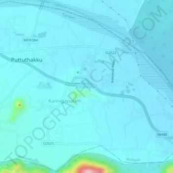
Name: KIlminnal topographic map, elevation, terrain.
Location: KIlminnal, Wallajah, Ranipet, Tamil Nadu, 632004, India (12.91791 79.22710 12.95791 79.26710)
Average elevation: 636 ft
Minimum elevation: 571 ft
Maximum elevation: 1,450 ft
Thank you for supporting this site ❤️
Make a donation
Make a donation
Gear up for your next adventure:
As an Amazon Associate, this site earns from qualifying purchases at no extra cost to you.
Other topographic maps
Click on a map to view its topography, its elevation and its terrain.