
Saint Cloud topographic map
Click on the map to display elevation.
About this map
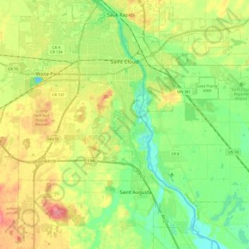
Name: Saint Cloud topographic map, elevation, terrain.
Location: Saint Cloud, Stearns County, Minnesota, United States (45.45248 -94.26341 45.59047 -94.03580)
Average elevation: 1,047 ft
Minimum elevation: 938 ft
Maximum elevation: 1,204 ft
Stearns County trails, hiking, mountain biking, running and outdoor activities
Other topographic maps
Click on a map to view its topography, its elevation and its terrain.
Pearl Lake
United States > Minnesota > Stearns County > Maine Prairie Township
Average elevation: 1,125 ft
Saint Anna Lake
United States > Minnesota > Stearns County > Krain Township
Average elevation: 1,247 ft