Geolocate

Rosebery topographic map

Click on the map to display elevation.

About this map

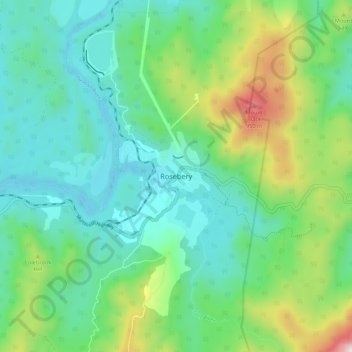
Name: Rosebery topographic map, elevation, terrain.

Location: Rosebery, Tasmania, Australia (-41.81869 145.50029 -41.73869 145.58029)

Average elevation: 1,178 ft

Minimum elevation: 344 ft

Maximum elevation: 3,576 ft

Gear up for your next adventure:

👖Convertible Hiking Pants - Versatile zip-off pants for changing altitudes and temperatures
🪶Camp Gear Gift Set - Perfect gift bundle for outdoor fans
Solar GPS Watches - Advanced multisport watches with built-in topographic maps
🪑Portable Camp Table - Compact table for campsite meals
🧢Sun Protection Hats - Wide-brimmed and UPF-rated hats for high-altitude sun safety

As an Amazon Associate, this site earns from qualifying purchases at no extra cost to you.