
Thank you for supporting this site ❤️
Make a donation
Make a donation
Gear up for your next adventure:
As an Amazon Associate, this site earns from qualifying purchases at no extra cost to you.
Alçıtepe topographic map
Click on the map to display elevation.
Thank you for supporting this site ❤️
Make a donation
Make a donation
Gear up for your next adventure:
As an Amazon Associate, this site earns from qualifying purchases at no extra cost to you.
About this map
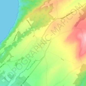
Name: Alçıtepe topographic map, elevation, terrain.
Location: Alçıtepe, Eceabat, Canakkale, Marmara Region, Turkey (40.07491 26.20730 40.11491 26.24730)
Average elevation: 315 ft
Minimum elevation: 0 ft
Maximum elevation: 686 ft
Thank you for supporting this site ❤️
Make a donation
Make a donation
Gear up for your next adventure:
As an Amazon Associate, this site earns from qualifying purchases at no extra cost to you.