
Make a donation
Gear up for your next adventure:
As an Amazon Associate, this site earns from qualifying purchases at no extra cost to you.
Hastings topographic map
Click on the map to display elevation.
Make a donation
Gear up for your next adventure:
As an Amazon Associate, this site earns from qualifying purchases at no extra cost to you.
About this map
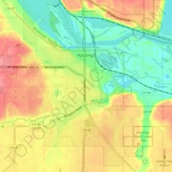
Name: Hastings topographic map, elevation, terrain.
Location: Hastings, Dakota County, Minnesota, 55033, United States (44.70231 -92.90032 44.77490 -92.81252)
Average elevation: 791 ft
Minimum elevation: 663 ft
Maximum elevation: 968 ft
Dakota County trails, hiking, mountain biking, running and outdoor activities
Make a donation
Gear up for your next adventure:
As an Amazon Associate, this site earns from qualifying purchases at no extra cost to you.
Other topographic maps
Click on a map to view its topography, its elevation and its terrain.
Burnsville
United States > Minnesota > Dakota County > Burnsville > Burnsville
Average elevation: 902 ft
Make a donation
Gear up for your next adventure:
As an Amazon Associate, this site earns from qualifying purchases at no extra cost to you.
Farmington
United States > Minnesota > Dakota County > Farmington > Farmington
Average elevation: 919 ft
Make a donation
Gear up for your next adventure:
As an Amazon Associate, this site earns from qualifying purchases at no extra cost to you.