
Thank you for supporting this site ❤️
Make a donation
Make a donation
Gear up for your next adventure:
As an Amazon Associate, this site earns from qualifying purchases at no extra cost to you.
Aseman abad topographic map
Click on the map to display elevation.
Thank you for supporting this site ❤️
Make a donation
Make a donation
Gear up for your next adventure:
As an Amazon Associate, this site earns from qualifying purchases at no extra cost to you.
About this map
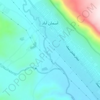
Name: Aseman abad topographic map, elevation, terrain.
Location: Aseman abad, بخش مرکزی, Chardavol County, Ilam Province, Iran (33.84177 46.44649 33.86727 46.47370)
Average elevation: 4,147 ft
Minimum elevation: 3,888 ft
Maximum elevation: 5,374 ft
Thank you for supporting this site ❤️
Make a donation
Make a donation
Gear up for your next adventure:
As an Amazon Associate, this site earns from qualifying purchases at no extra cost to you.
Other topographic maps
Click on a map to view its topography, its elevation and its terrain.
Asemanabad- Ghalaje Paraglider Takeoff Site
Iran > Ilam Province > Chardavol County > Kol Kol Rural District
Average elevation: 5,732 ft