
Make a donation
Gear up for your next adventure:
As an Amazon Associate, this site earns from qualifying purchases at no extra cost to you.
Frickenfelden topographic map
Click on the map to display elevation.
Make a donation
Gear up for your next adventure:
As an Amazon Associate, this site earns from qualifying purchases at no extra cost to you.
About this map
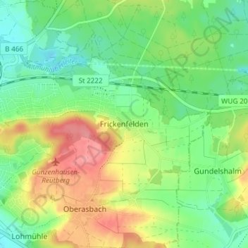
Name: Frickenfelden topographic map, elevation, terrain.
Average elevation: 1,463 ft
Minimum elevation: 1,355 ft
Maximum elevation: 1,621 ft
Make a donation
Gear up for your next adventure:
As an Amazon Associate, this site earns from qualifying purchases at no extra cost to you.
Other topographic maps
Click on a map to view its topography, its elevation and its terrain.
Altmühlsee
Deutschland > Bayern > Landkreis Weißenburg-Gunzenhausen > Gunzenhausen > Streudorf
Average elevation: 1,368 ft
91710
Deutschland > Bayern > Landkreis Weißenburg-Gunzenhausen > Gunzenhausen > Schlungenhof > Scheupeleinsmühle
Average elevation: 1,371 ft