Geolocate

Hanau topographic map

Click on the map to display elevation.

About this map

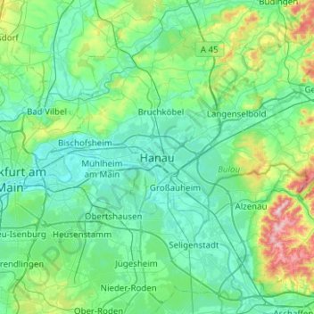
Name: Hanau topographic map, elevation, terrain.

Location: Hanau, Schöneck, Main-Kinzig-Kreis, Hesse, 63450, Germany (50.09288 8.87698 50.17288 8.95698)

Average elevation: 361 ft

Minimum elevation: 318 ft

Maximum elevation: 476 ft

Other topographic maps

Click on a map to view its topography, its elevation and its terrain.

Klein-Auheim

Germany > Hesse > Main-Kinzig-Kreis > Hanau

Average elevation: 358 ft

Gear up for your next adventure:

🛌Ultralight Sleeping Bags - Compact down bags for cold nights in the wilderness
🏔️Mountain Trail Maps - High‑detail maps for popular peaks
🛠️Backpacking Tool Kit - Essential toolkit for outdoor repairs
🏫Relief Map Kits - Hands-on tools for teaching landforms and elevation
👟Trail Running Shoes - Lightweight shoes for trail runners

As an Amazon Associate, this site earns from qualifying purchases at no extra cost to you.