
Make a donation
Gear up for your next adventure:
As an Amazon Associate, this site earns from qualifying purchases at no extra cost to you.
Böckweiler topographic map
Click on the map to display elevation.
Make a donation
Gear up for your next adventure:
As an Amazon Associate, this site earns from qualifying purchases at no extra cost to you.
Böckweiler
Böckweiler liegt im Südosten des Bliesgaus rund 7 km südsüdöstlich von Blieskastel auf einer Höhe von 301 m ü. NHN. Etwas nordwestlich erhebt sich der Große Kahlenberg mit der Ruine des 1939 gesprengten Alexanderturms (auch Böckweiler Aussichtsturm).
Make a donation
Gear up for your next adventure:
As an Amazon Associate, this site earns from qualifying purchases at no extra cost to you.
About this map
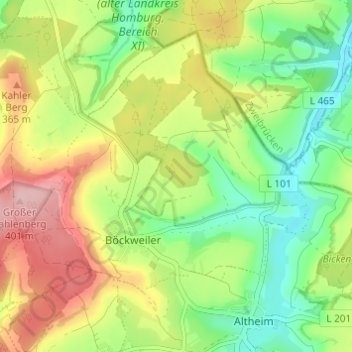
Name: Böckweiler topographic map, elevation, terrain.
Location: Böckweiler, Blieskastel, Saarpfalz-Kreis, Saarland, Deutschland (49.17278 7.26241 49.20565 7.32326)
Average elevation: 1,017 ft
Minimum elevation: 771 ft
Maximum elevation: 1,342 ft
Make a donation
Gear up for your next adventure:
As an Amazon Associate, this site earns from qualifying purchases at no extra cost to you.
Other topographic maps
Click on a map to view its topography, its elevation and its terrain.
Bierbach
Deutschland > Saarland > Saarpfalz-Kreis > Blieskastel
Der Gollenstein wurde vor 4000 Jahren errichtet. Er gilt als der größte Menhir Mitteleuropas und als eines der ältesten Kulturdenkmäler in Deutschland. Zwölf Grabhügel an der Straße von Böckweiler nach Mimbach stammen aus der Hallstattzeit. Auf dem Höhenrücken zwischen Wolfersheim und Rubenheim…
Average elevation: 902 ft