
Thank you for supporting this site ❤️
Make a donation
Make a donation
Gear up for your next adventure:
As an Amazon Associate, this site earns from qualifying purchases at no extra cost to you.
Sassel topographic map
Click on the map to display elevation.
Thank you for supporting this site ❤️
Make a donation
Make a donation
Gear up for your next adventure:
As an Amazon Associate, this site earns from qualifying purchases at no extra cost to you.
About this map
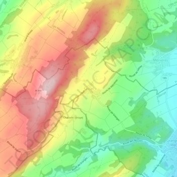
Name: Sassel topographic map, elevation, terrain.
Location: Sassel, Valbroye, District de la Broye-Vully, Vaud, 1534, Suisse (46.75662 6.83710 46.79662 6.87710)
Average elevation: 2,001 ft
Minimum elevation: 1,542 ft
Maximum elevation: 2,500 ft
Thank you for supporting this site ❤️
Make a donation
Make a donation
Gear up for your next adventure:
As an Amazon Associate, this site earns from qualifying purchases at no extra cost to you.