
Soweto topographic map
Click on the map to display elevation.
About this map
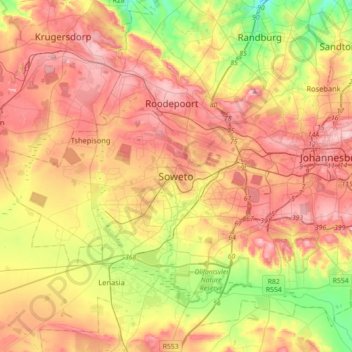
Name: Soweto topographic map, elevation, terrain.
Average elevation: 5,374 ft
Minimum elevation: 4,711 ft
Maximum elevation: 6,007 ft
Other topographic maps
Click on a map to view its topography, its elevation and its terrain.
Johannesburg Botanical Gardens
South Africa > Gauteng > City of Johannesburg Metropolitan Municipality > Johannesburg
Average elevation: 5,358 ft
Roodepoort
South Africa > Gauteng > City of Johannesburg Metropolitan Municipality
Average elevation: 5,226 ft
Klipriviersberg Nature Reserve
South Africa > Gauteng > City of Johannesburg Metropolitan Municipality > Johannesburg
Average elevation: 5,361 ft
Melville Koppies
South Africa > Gauteng > City of Johannesburg Metropolitan Municipality > Johannesburg
Average elevation: 5,502 ft
Melville Koppies Central
South Africa > Gauteng > City of Johannesburg Metropolitan Municipality > Johannesburg
Average elevation: 5,466 ft
Emmarentia Dam
South Africa > Gauteng > City of Johannesburg Metropolitan Municipality > Johannesburg
Average elevation: 5,285 ft
Delta Park
South Africa > Gauteng > City of Johannesburg Metropolitan Municipality > Rosebank
Average elevation: 5,210 ft
Emmarentia Dog Park
South Africa > Gauteng > City of Johannesburg Metropolitan Municipality > Johannesburg
Average elevation: 5,384 ft
Zoo Lake
South Africa > Gauteng > City of Johannesburg Metropolitan Municipality > Rosebank
Average elevation: 5,404 ft
Jukskei River
South Africa > Gauteng > City of Johannesburg Metropolitan Municipality
Average elevation: 5,013 ft
Klip River
South Africa > Gauteng > City of Johannesburg Metropolitan Municipality
Average elevation: 5,144 ft
George Hay Park
South Africa > Gauteng > City of Johannesburg Metropolitan Municipality > Johannesburg
Average elevation: 5,407 ft
Emmarentia Fountain
South Africa > Gauteng > City of Johannesburg Metropolitan Municipality > Johannesburg
Average elevation: 5,289 ft
Jukskei Park
South Africa > Gauteng > City of Johannesburg Metropolitan Municipality > Randburg
Average elevation: 4,682 ft
Victory Park
South Africa > Gauteng > City of Johannesburg Metropolitan Municipality > Johannesburg
Average elevation: 5,240 ft
Klipspruit
South Africa > Gauteng > City of Johannesburg Metropolitan Municipality > Soweto
Average elevation: 5,249 ft
Thokoza Park
South Africa > Gauteng > City of Johannesburg Metropolitan Municipality > Soweto
Average elevation: 5,262 ft
Modderfontein Reserve
South Africa > Gauteng > City of Johannesburg Metropolitan Municipality > Sandton
Average elevation: 5,026 ft
Kruger Park
South Africa > Gauteng > City of Johannesburg Metropolitan Municipality > Roodepoort
Average elevation: 5,604 ft
Kew
South Africa > Gauteng > City of Johannesburg Metropolitan Municipality
Average elevation: 5,253 ft
Roodepoort
South Africa > Gauteng > City of Johannesburg Metropolitan Municipality
Average elevation: 5,226 ft
Thokoza Park
South Africa > Gauteng > City of Johannesburg Metropolitan Municipality > Soweto
Average elevation: 5,262 ft
Vacant land
South Africa > Gauteng > City of Johannesburg Metropolitan Municipality > Johannesburg
Average elevation: 5,587 ft
Klip River
South Africa > Gauteng > City of Johannesburg Metropolitan Municipality
Average elevation: 5,036 ft
Klipspruit
South Africa > Gauteng > City of Johannesburg Metropolitan Municipality > Soweto
Average elevation: 5,249 ft
Emmarentia Dam
South Africa > Gauteng > City of Johannesburg Metropolitan Municipality > Johannesburg
Average elevation: 5,285 ft
Klip River
South Africa > Gauteng > City of Johannesburg Metropolitan Municipality
Average elevation: 5,036 ft
Jukskei River
South Africa > Gauteng > City of Johannesburg Metropolitan Municipality
Average elevation: 5,013 ft
Emmarentia Dam
South Africa > Gauteng > City of Johannesburg Metropolitan Municipality > Johannesburg
Average elevation: 5,285 ft
Roodepoort
South Africa > Gauteng > City of Johannesburg Metropolitan Municipality
Average elevation: 5,226 ft
Klipspruit
South Africa > Gauteng > City of Johannesburg Metropolitan Municipality > Soweto
Average elevation: 5,249 ft
Roodepoort
South Africa > Gauteng > City of Johannesburg Metropolitan Municipality
Average elevation: 5,230 ft
Jukskei River
South Africa > Gauteng > City of Johannesburg Metropolitan Municipality
Average elevation: 5,013 ft
Zoo Lake
South Africa > Gauteng > City of Johannesburg Metropolitan Municipality > Rosebank
Average elevation: 5,404 ft
Delta Park
South Africa > Gauteng > City of Johannesburg Metropolitan Municipality > Rosebank
Average elevation: 5,210 ft
Alexander Park
South Africa > Gauteng > City of Johannesburg Metropolitan Municipality > Johannesburg
Average elevation: 5,607 ft
Melville Koppies
South Africa > Gauteng > City of Johannesburg Metropolitan Municipality > Johannesburg
Average elevation: 5,502 ft
Roodepoort
South Africa > Gauteng > City of Johannesburg Metropolitan Municipality
Average elevation: 5,230 ft
Eldoret Park
South Africa > Gauteng > City of Johannesburg Metropolitan Municipality > Sandton
Average elevation: 4,724 ft
Melville Koppies
South Africa > Gauteng > City of Johannesburg Metropolitan Municipality > Johannesburg
Average elevation: 5,502 ft
Darrenwood Park
South Africa > Gauteng > City of Johannesburg Metropolitan Municipality > Johannesburg
Average elevation: 5,243 ft
Roodepoort
South Africa > Gauteng > City of Johannesburg Metropolitan Municipality
Average elevation: 5,226 ft
Chartwell Gardens
South Africa > Gauteng > City of Johannesburg Metropolitan Municipality > Johannesburg
Average elevation: 5,587 ft