
Make a donation
Gear up for your next adventure:
As an Amazon Associate, this site earns from qualifying purchases at no extra cost to you.
Leadington topographic map
Click on the map to display elevation.
Make a donation
Gear up for your next adventure:
As an Amazon Associate, this site earns from qualifying purchases at no extra cost to you.
About this map
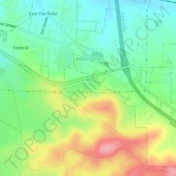
Name: Leadington topographic map, elevation, terrain.
Location: Leadington, St. Francois County, Missouri, United States (37.82358 -90.49460 37.84793 -90.46663)
Average elevation: 919 ft
Minimum elevation: 778 ft
Maximum elevation: 1,145 ft
St. Francois County trails, hiking, mountain biking, running and outdoor activities
Make a donation
Gear up for your next adventure:
As an Amazon Associate, this site earns from qualifying purchases at no extra cost to you.
Other topographic maps
Click on a map to view its topography, its elevation and its terrain.
Make a donation
Gear up for your next adventure:
As an Amazon Associate, this site earns from qualifying purchases at no extra cost to you.
Bonne Terre
United States > Missouri > St. Francois County > Bonne Terre > Bonne Terre
Average elevation: 784 ft