Geolocate

Silver Star topographic map

Click on the map to display elevation.

About this map

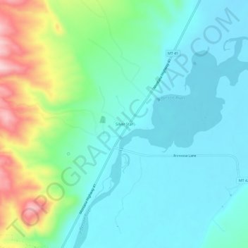
Name: Silver Star topographic map, elevation, terrain.

Location: Silver Star, Madison County, Montana, 59751, United States (45.67024 -112.30306 45.71024 -112.26306)

Average elevation: 4,685 ft

Minimum elevation: 4,478 ft

Maximum elevation: 5,325 ft

Madison County trails, hiking, mountain biking, running and outdoor activities

Other topographic maps

Click on a map to view its topography, its elevation and its terrain.

Ennis

United States > Montana > Madison County

Average elevation: 4,964 ft

Alder

United States > Montana > Madison County

Average elevation: 5,230 ft

Twin Bridges

United States > Montana > Madison County

Average elevation: 4,639 ft

Alder

United States > Montana > Madison County

Average elevation: 5,230 ft

Alder

United States > Montana > Madison County

Average elevation: 5,230 ft

Gear up for your next adventure:

🪓Survival Multi‑Tool - Versatile tool for camp and trail tasks
🪶Fire Starter Kit - Reliable fire starter for survival and camping
🌎3D Topographic Globes - Raised relief globes for a tactile understanding of geography
🎒Hydration Pack - Hands‑free water reservoir for long hikes
🧭GPS Watch Accessories - Bands and chargers for GPS watches

As an Amazon Associate, this site earns from qualifying purchases at no extra cost to you.