
Thank you for supporting this site ❤️
Make a donation
Make a donation
Gear up for your next adventure:
As an Amazon Associate, this site earns from qualifying purchases at no extra cost to you.
Varolino topographic map
Click on the map to display elevation.
Thank you for supporting this site ❤️
Make a donation
Make a donation
Gear up for your next adventure:
As an Amazon Associate, this site earns from qualifying purchases at no extra cost to you.
About this map
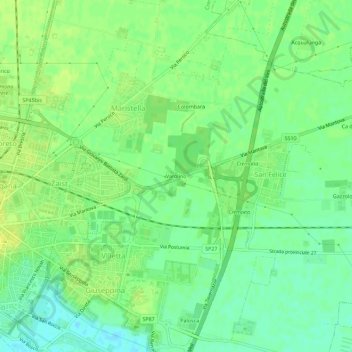
Name: Varolino topographic map, elevation, terrain.
Location: Varolino, San Felice, Cremona, Lombardy, 26100, Italy (45.12277 10.04060 45.16277 10.08060)
Average elevation: 148 ft
Minimum elevation: 115 ft
Maximum elevation: 171 ft
Thank you for supporting this site ❤️
Make a donation
Make a donation
Gear up for your next adventure:
As an Amazon Associate, this site earns from qualifying purchases at no extra cost to you.