
Rzędkowice topographic map
Interactive map
Click on the map to display elevation.
About this map
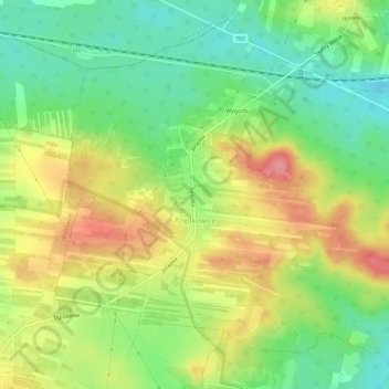
Name: Rzędkowice topographic map, elevation, terrain.
Average elevation: 1,240 ft
Minimum elevation: 1,102 ft
Maximum elevation: 1,407 ft
Other topographic maps
Click on a map to view its topography, its elevation and its terrain.
Poręba
Poland > Silesian Voivodeship > Zawiercie County > Poręba
Poręba, Zawiercie County, Silesian Voivodeship, 42-480, Poland
Average elevation: 1,066 ft
Kleszczowa
Poland > Silesian Voivodeship > Zawiercie County
Kleszczowa, gmina Pilica, Zawiercie County, Silesian Voivodeship, 42-436, Poland
Average elevation: 1,109 ft
Wygoda
Poland > Silesian Voivodeship > Zawiercie County > Rzędkowice
Wygoda, Rzędkowice, gmina Włodowice, Zawiercie County, Silesian Voivodeship, 42-421, Poland
Average elevation: 1,234 ft
Zawiercie
Poland > Silesian Voivodeship > Zawiercie County > Zawiercie
Zawiercie, Zawiercie County, Silesian Voivodeship, 42-400, Poland
Average elevation: 1,135 ft