
Make a donation
Gear up for your next adventure:
As an Amazon Associate, this site earns from qualifying purchases at no extra cost to you.
Khartoum topographic map
Click on the map to display elevation.
Make a donation
Gear up for your next adventure:
As an Amazon Associate, this site earns from qualifying purchases at no extra cost to you.
Khartoum
Khartoum is relatively flat, at elevation 385 m (1,263 ft), as the Nile flows northeast past Omdurman to Shendi, at elevation 364 m (1,194 ft) about 101 miles (163 km) away.
Make a donation
Gear up for your next adventure:
As an Amazon Associate, this site earns from qualifying purchases at no extra cost to you.
About this map
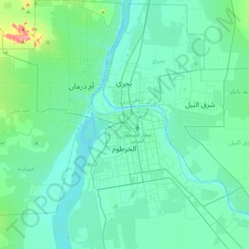
Name: Khartoum topographic map, elevation, terrain.
Location: Khartoum, Khartoum State, 11111, Sudan (15.40360 32.37491 15.72360 32.69491)
Average elevation: 1,273 ft
Minimum elevation: 1,220 ft
Maximum elevation: 1,621 ft
Make a donation
Gear up for your next adventure:
As an Amazon Associate, this site earns from qualifying purchases at no extra cost to you.
Other topographic maps
Click on a map to view its topography, its elevation and its terrain.