
Make a donation
Gear up for your next adventure:
As an Amazon Associate, this site earns from qualifying purchases at no extra cost to you.
Gibson County Lake topographic map
Click on the map to display elevation.
Make a donation
Gear up for your next adventure:
As an Amazon Associate, this site earns from qualifying purchases at no extra cost to you.
About this map
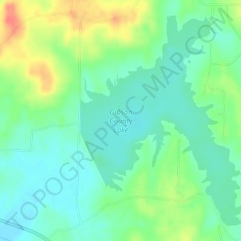
Name: Gibson County Lake topographic map, elevation, terrain.
Average elevation: 384 ft
Minimum elevation: 325 ft
Maximum elevation: 499 ft
Gibson County trails, hiking, mountain biking, running and outdoor activities
Make a donation
Gear up for your next adventure:
As an Amazon Associate, this site earns from qualifying purchases at no extra cost to you.
Other topographic maps
Click on a map to view its topography, its elevation and its terrain.
Milan
United States > Tennessee > Gibson County
Milan is approximately 100 miles (160 km) Northeast of Memphis and 140 miles (230 km) West of Nashville, at an elevation of 424 feet (129 m) above sea level.
Average elevation: 427 ft
Make a donation
Gear up for your next adventure:
As an Amazon Associate, this site earns from qualifying purchases at no extra cost to you.