Geolocate

Gladys topographic map

Click on the map to display elevation.

About this map

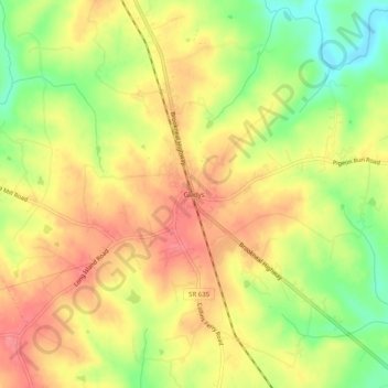
Name: Gladys topographic map, elevation, terrain.

Location: Gladys, Campbell County, Virginia, 24554, United States (37.14320 -79.09363 37.18320 -79.05363)

Average elevation: 715 ft

Minimum elevation: 574 ft

Maximum elevation: 817 ft

Campbell County trails, hiking, mountain biking, running and outdoor activities

Other topographic maps

Click on a map to view its topography, its elevation and its terrain.

Concord

United States > Virginia > Campbell County > Concord

Average elevation: 804 ft

Altavista

United States > Virginia > Campbell County

Average elevation: 656 ft

Gear up for your next adventure:

🏕️Family Camping Gear - Essentials for group camping trips
🛡️Insect Repellent - Protection against bugs during outdoor activities
🪓Survival Multi‑Tool - Versatile tool for camp and trail tasks
📱Heavy-Duty Phone Cases - Drop-proof and waterproof protection for outdoor navigation
🎒Day Hiking Backpack - Lightweight backpack perfect for day trips and outdoor adventures

As an Amazon Associate, this site earns from qualifying purchases at no extra cost to you.