
Make a donation
Gear up for your next adventure:
As an Amazon Associate, this site earns from qualifying purchases at no extra cost to you.
Pucking topographic map
Click on the map to display elevation.
Make a donation
Gear up for your next adventure:
As an Amazon Associate, this site earns from qualifying purchases at no extra cost to you.
About this map
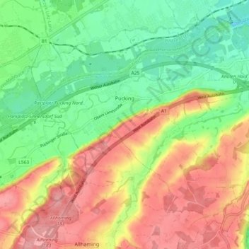
Name: Pucking topographic map, elevation, terrain.
Location: Pucking, Bezirk Linz-Land, Upper Austria, 4055, Austria (48.15759 14.15413 48.20699 14.24500)
Average elevation: 1,030 ft
Minimum elevation: 856 ft
Maximum elevation: 1,230 ft
Make a donation
Gear up for your next adventure:
As an Amazon Associate, this site earns from qualifying purchases at no extra cost to you.
Other topographic maps
Click on a map to view its topography, its elevation and its terrain.
Make a donation
Gear up for your next adventure:
As an Amazon Associate, this site earns from qualifying purchases at no extra cost to you.
Enzenwinkl
Austria > Upper Austria > Bezirk Linz-Land > Leonding > Enzenwinkl
Average elevation: 1,083 ft