
Make a donation
Gear up for your next adventure:
As an Amazon Associate, this site earns from qualifying purchases at no extra cost to you.
Le Mont topographic map
Click on the map to display elevation.
Make a donation
Gear up for your next adventure:
As an Amazon Associate, this site earns from qualifying purchases at no extra cost to you.
About this map
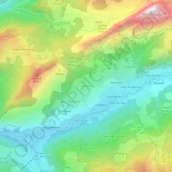
Name: Le Mont topographic map, elevation, terrain.
Average elevation: 4,327 ft
Minimum elevation: 2,995 ft
Maximum elevation: 6,765 ft
Make a donation
Gear up for your next adventure:
As an Amazon Associate, this site earns from qualifying purchases at no extra cost to you.
Other topographic maps
Click on a map to view its topography, its elevation and its terrain.
Les Saix de Miolène
France > Auvergne-Rhône-Alpes > Haute-Savoie > Abondance > Sous les Saix
Average elevation: 4,190 ft
74360
France > Auvergne-Rhône-Alpes > Haute-Savoie > Abondance > La Plaine Joux
Average elevation: 4,751 ft
Make a donation
Gear up for your next adventure:
As an Amazon Associate, this site earns from qualifying purchases at no extra cost to you.
Lac de Tavaneuse
France > Auvergne-Rhône-Alpes > Haute-Savoie > Abondance > Châlets de Tavaneuse
C'est un lac de montagne de forme quasi-losangique et situé à environ 1 805 mètres d'altitude dans un cirque glaciaire au pied de la petite pointe du Piron (2 145 mètres) et du Piron (2 054 mètres). Le lac est occupé dans sa partie sud-est par un petite île de 1 400 m2 résultant de l'effondrement de la…
Average elevation: 5,889 ft