Geolocate

Digebouy topographic map

Click on the map to display elevation.

About this map

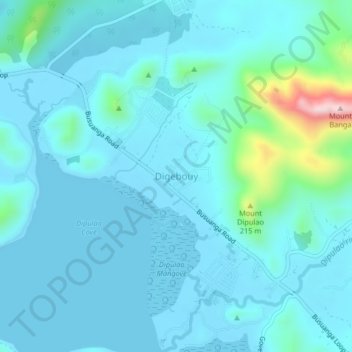
Name: Digebouy topographic map, elevation, terrain.

Location: Digebouy, Coron, Palawan, Mimaropa, 5316, Philippines (12.00921 120.15860 12.04921 120.19860)

Average elevation: 154 ft

Minimum elevation: -7 ft

Maximum elevation: 1,309 ft

Other topographic maps

Click on a map to view its topography, its elevation and its terrain.

Apo Island

Philippines > Palawan > Coron

Average elevation: 72 ft

Mayanpayan Island

Philippines > Palawan > Coron

Average elevation: 23 ft

Coron Island

Philippines > Palawan > Coron

Average elevation: 121 ft

Pedrasa Island

Philippines > Palawan > Coron

Average elevation: 59 ft

Bulalacao

Philippines > Palawan > Coron

Average elevation: 10 ft

Bulalacao

Philippines > Palawan > Coron

Average elevation: 10 ft

Gear up for your next adventure:

🧦Merino Wool Socks - Moisture-wicking, blister-preventing socks for long treks
🥩Freeze-Dried Meals - Nutritious and lightweight food for remote expeditions
🌧️Backpack Rain Cover - Keep gear dry in wet weather
🩹Survival Bandages - High‑quality bandages for emergencies
👖Convertible Hiking Pants - Versatile zip-off pants for changing altitudes and temperatures

As an Amazon Associate, this site earns from qualifying purchases at no extra cost to you.