
Thank you for supporting this site ❤️
Make a donation
Make a donation
Gear up for your next adventure:
As an Amazon Associate, this site earns from qualifying purchases at no extra cost to you.
Hazelbrook topographic map
Click on the map to display elevation.
Thank you for supporting this site ❤️
Make a donation
Make a donation
Gear up for your next adventure:
As an Amazon Associate, this site earns from qualifying purchases at no extra cost to you.
About this map
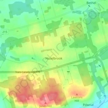
Name: Hazelbrook topographic map, elevation, terrain.
Location: Hazelbrook, Queens County, Prince Edward Island, Canada (46.20986 -63.03555 46.23682 -62.97134)
Average elevation: 121 ft
Minimum elevation: -3 ft
Maximum elevation: 302 ft
Thank you for supporting this site ❤️
Make a donation
Make a donation
Gear up for your next adventure:
As an Amazon Associate, this site earns from qualifying purchases at no extra cost to you.