
Thank you for supporting this site ❤️
Make a donation
Make a donation
Gear up for your next adventure:
As an Amazon Associate, this site earns from qualifying purchases at no extra cost to you.
El Cielo topographic map
Click on the map to display elevation.
Thank you for supporting this site ❤️
Make a donation
Make a donation
Gear up for your next adventure:
As an Amazon Associate, this site earns from qualifying purchases at no extra cost to you.
About this map
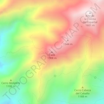
Name: El Cielo topographic map, elevation, terrain.
Location: El Cielo, Nerja, La Axarquía, Málaga, Andalucía, España (36.80480 -3.81511 36.80490 -3.81501)
Average elevation: 3,835 ft
Minimum elevation: 2,375 ft
Maximum elevation: 5,217 ft
Thank you for supporting this site ❤️
Make a donation
Make a donation
Gear up for your next adventure:
As an Amazon Associate, this site earns from qualifying purchases at no extra cost to you.
Other topographic maps
Click on a map to view its topography, its elevation and its terrain.
Paraje Natural Acantilados de Maro-Cerro Gordo
España > Andalucía > La Axarquía > Nerja
Average elevation: 276 ft