
Make a donation
Gear up for your next adventure:
As an Amazon Associate, this site earns from qualifying purchases at no extra cost to you.
Bière topographic map
Click on the map to display elevation.
Make a donation
Gear up for your next adventure:
As an Amazon Associate, this site earns from qualifying purchases at no extra cost to you.
Bière
La commune s'étage d'une altitude de 569 mètres à la confluence du Toleure et de l'Aubonne à 1 606 mètres au Grand Cunay. Le Veyron et l'Aubonne prennent leur source sur la commune.
Make a donation
Gear up for your next adventure:
As an Amazon Associate, this site earns from qualifying purchases at no extra cost to you.
About this map
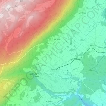
Name: Bière topographic map, elevation, terrain.
Location: Bière, District de Morges, Vaud, 1145, Suisse (46.51648 6.26454 46.58118 6.37328)
Average elevation: 2,982 ft
Minimum elevation: 1,772 ft
Maximum elevation: 5,276 ft
Make a donation
Gear up for your next adventure:
As an Amazon Associate, this site earns from qualifying purchases at no extra cost to you.
Other topographic maps
Click on a map to view its topography, its elevation and its terrain.
Make a donation
Gear up for your next adventure:
As an Amazon Associate, this site earns from qualifying purchases at no extra cost to you.