
Make a donation
Gear up for your next adventure:
As an Amazon Associate, this site earns from qualifying purchases at no extra cost to you.
McConnellsburg topographic map
Click on the map to display elevation.
Make a donation
Gear up for your next adventure:
As an Amazon Associate, this site earns from qualifying purchases at no extra cost to you.
McConnellsburg
According to the United States Census Bureau, the borough has a total area of 0.35 square miles (0.9 km2), all land. The elevation in the center of town is 896 feet (273 m) above sea level.
Make a donation
Gear up for your next adventure:
As an Amazon Associate, this site earns from qualifying purchases at no extra cost to you.
About this map
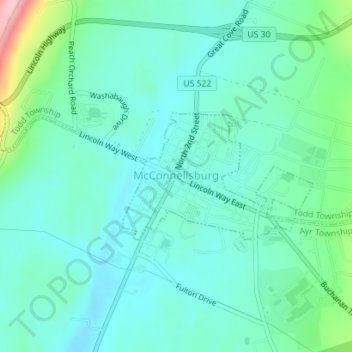
Name: McConnellsburg topographic map, elevation, terrain.
Location: McConnellsburg, Fulton County, Pennsylvania, United States (39.92710 -78.00419 39.93737 -77.98627)
Average elevation: 951 ft
Minimum elevation: 823 ft
Maximum elevation: 1,444 ft
Fulton County trails, hiking, mountain biking, running and outdoor activities
Make a donation
Gear up for your next adventure:
As an Amazon Associate, this site earns from qualifying purchases at no extra cost to you.
Other topographic maps
Click on a map to view its topography, its elevation and its terrain.
Make a donation
Gear up for your next adventure:
As an Amazon Associate, this site earns from qualifying purchases at no extra cost to you.