
Thank you for supporting this site ❤️
Make a donation
Make a donation
Gear up for your next adventure:
As an Amazon Associate, this site earns from qualifying purchases at no extra cost to you.
Bole topographic map
Click on the map to display elevation.
Thank you for supporting this site ❤️
Make a donation
Make a donation
Gear up for your next adventure:
As an Amazon Associate, this site earns from qualifying purchases at no extra cost to you.
About this map
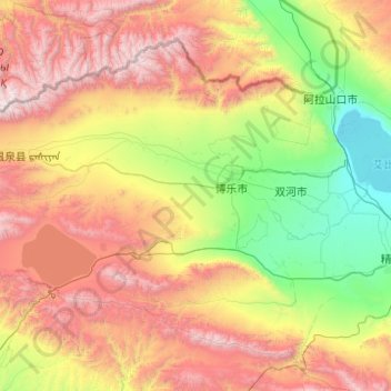
Name: Bole topographic map, elevation, terrain.
Location: Bole, Bortala Mongol Autonomous Prefecture, Xinjiang, China (44.12024 81.17150 45.52024 82.57150)
Average elevation: 4,777 ft
Minimum elevation: 633 ft
Maximum elevation: 13,389 ft
Thank you for supporting this site ❤️
Make a donation
Make a donation
Gear up for your next adventure:
As an Amazon Associate, this site earns from qualifying purchases at no extra cost to you.