
Thank you for supporting this site ❤️
Make a donation
Make a donation
Gear up for your next adventure:
As an Amazon Associate, this site earns from qualifying purchases at no extra cost to you.
Snodland topographic map
Click on the map to display elevation.
Thank you for supporting this site ❤️
Make a donation
Make a donation
Gear up for your next adventure:
As an Amazon Associate, this site earns from qualifying purchases at no extra cost to you.
About this map
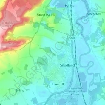
Name: Snodland topographic map, elevation, terrain.
Location: Snodland, Tonbridge and Malling, Kent, England, United Kingdom (51.31688 0.39016 51.35296 0.46043)
Average elevation: 128 ft
Minimum elevation: -16 ft
Maximum elevation: 584 ft
Thank you for supporting this site ❤️
Make a donation
Make a donation
Gear up for your next adventure:
As an Amazon Associate, this site earns from qualifying purchases at no extra cost to you.
Other topographic maps
Click on a map to view its topography, its elevation and its terrain.
Holborough Lakes
United Kingdom > England > Kent > Tonbridge and Malling > Snodland
Average elevation: 105 ft