
Make a donation
Gear up for your next adventure:
As an Amazon Associate, this site earns from qualifying purchases at no extra cost to you.
Auerberg topographic map
Click on the map to display elevation.
Make a donation
Gear up for your next adventure:
As an Amazon Associate, this site earns from qualifying purchases at no extra cost to you.
Auerberg
Im 14. Jahrhundert errichtete die Stadt Bonn in der Gemarkung up der Hüh (an der heutigen Kreuzung von Kölnstraße und An der Josefshöhe) ein Siechenhaus, zu dem 1412 eine Lazarus-Kapelle hinzukam. 1713 wurde das Siechenhaus geschlossen und von der städtischen Armenverwaltung als Gutshof weitergeführt. 1868 wurde das Gelände vom Katholischen Verein in Bonn erworben, der dort 1872 die Erziehungsanstalt St. Joseph an der Höhe (das heutige Collegium Josephinum) als Waisenhaus errichtete. Die Lazarus-Kapelle wurde 1883 abgerissen und bis 1886 durch einen neugotischen Kirchenbau ersetzt.
Make a donation
Gear up for your next adventure:
As an Amazon Associate, this site earns from qualifying purchases at no extra cost to you.
About this map
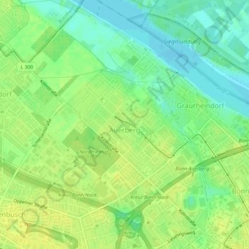
Name: Auerberg topographic map, elevation, terrain.
Average elevation: 187 ft
Minimum elevation: 151 ft
Maximum elevation: 217 ft
Make a donation
Gear up for your next adventure:
As an Amazon Associate, this site earns from qualifying purchases at no extra cost to you.
Other topographic maps
Click on a map to view its topography, its elevation and its terrain.
Bonn
Deutschland > Nordrhein-Westfalen > Bonn
Bonn hat seinen geografischen Mittelpunkt am Bundeskanzlerplatz, der sich im Ortsteil Gronau befindet. Die geografische Lage des Platzes ist 50° 43′ 8,8″ N, 7° 7′ 3,3″ O50.7191138888897.1175722222222. Die Bonner Innenstadt, die nicht zum Rhein hin ausgerichtet ist, liegt auf einer Höhe von 56 m bis 61 m ü. NHN.
Average elevation: 453 ft
Make a donation
Gear up for your next adventure:
As an Amazon Associate, this site earns from qualifying purchases at no extra cost to you.
Oberholtorf
Deutschland > Nordrhein-Westfalen > Bonn > Holtorf > Oberholtorf
Average elevation: 443 ft