
Thank you for supporting this site ❤️
Make a donation
Make a donation
Gear up for your next adventure:
As an Amazon Associate, this site earns from qualifying purchases at no extra cost to you.
Pewsey topographic map
Click on the map to display elevation.
Thank you for supporting this site ❤️
Make a donation
Make a donation
Gear up for your next adventure:
As an Amazon Associate, this site earns from qualifying purchases at no extra cost to you.
About this map
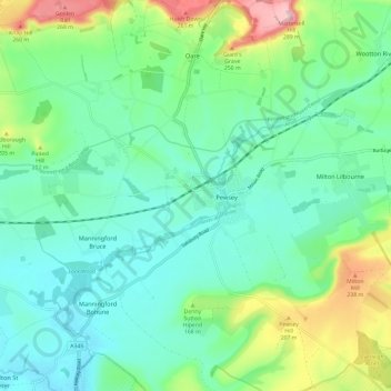
Name: Pewsey topographic map, elevation, terrain.
Location: Pewsey, Wiltshire, South West England, England, United Kingdom (51.30238 -1.79796 51.37679 -1.72426)
Average elevation: 479 ft
Minimum elevation: 305 ft
Maximum elevation: 968 ft
Thank you for supporting this site ❤️
Make a donation
Make a donation
Gear up for your next adventure:
As an Amazon Associate, this site earns from qualifying purchases at no extra cost to you.