
Make a donation
Gear up for your next adventure:
As an Amazon Associate, this site earns from qualifying purchases at no extra cost to you.
Weltersbach topographic map
Click on the map to display elevation.
Make a donation
Gear up for your next adventure:
As an Amazon Associate, this site earns from qualifying purchases at no extra cost to you.
Weltersbach
Weitere Nachbarorte sind Unterbüscherhof, Ufer, Holzerhof, Schüddig, Metzholz, Schneppenpohl, Krabbenhäuschen, Scheuerhof, Friedrichshöhe, Koltershäuschen, Bremersheide, Neuwinkel, Hinterberg und Sankt Heribert. Abgegangen ist Bremersheidermühle.
Make a donation
Gear up for your next adventure:
As an Amazon Associate, this site earns from qualifying purchases at no extra cost to you.
About this map
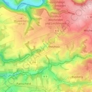
Name: Weltersbach topographic map, elevation, terrain.
Average elevation: 545 ft
Minimum elevation: 217 ft
Maximum elevation: 817 ft
Make a donation
Gear up for your next adventure:
As an Amazon Associate, this site earns from qualifying purchases at no extra cost to you.
Other topographic maps
Click on a map to view its topography, its elevation and its terrain.
42799
Deutschland > Nordrhein-Westfalen > Rheinisch-Bergischer Kreis > Leichlingen > Metzholz > Koltershäuschen
Average elevation: 469 ft