
Thank you for supporting this site ❤️
Make a donation
Make a donation
Gear up for your next adventure:
As an Amazon Associate, this site earns from qualifying purchases at no extra cost to you.
Peneda topographic map
Click on the map to display elevation.
Thank you for supporting this site ❤️
Make a donation
Make a donation
Gear up for your next adventure:
As an Amazon Associate, this site earns from qualifying purchases at no extra cost to you.
About this map
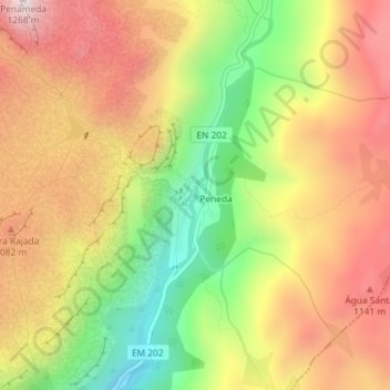
Name: Peneda topographic map, elevation, terrain.
Location: Peneda, Viana do Castelo, North, 4970-150, Portugal (41.96895 -8.22436 41.97934 -8.21929)
Average elevation: 3,028 ft
Minimum elevation: 1,798 ft
Maximum elevation: 4,101 ft
Thank you for supporting this site ❤️
Make a donation
Make a donation
Gear up for your next adventure:
As an Amazon Associate, this site earns from qualifying purchases at no extra cost to you.