
Lindström topographic map
Click on the map to display elevation.
About this map
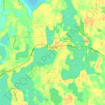
Name: Lindström topographic map, elevation, terrain.
Location: Lindström, Chisago County, Minnesota, 55045, United States (45.35054 -92.87827 45.42148 -92.81200)
Average elevation: 912 ft
Minimum elevation: 863 ft
Maximum elevation: 961 ft
Chisago County trails, hiking, mountain biking, running and outdoor activities
Other topographic maps
Click on a map to view its topography, its elevation and its terrain.
Moody Lake
United States > Minnesota > Chisago County > Chisago Lake Township
Average elevation: 928 ft