Geolocate

Whitfield topographic map

Click on the map to display elevation.

About this map

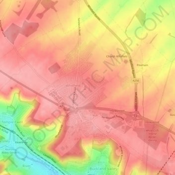
Name: Whitfield topographic map, elevation, terrain.

Location: Whitfield, Dover, Kent, England, United Kingdom (51.14259 1.26325 51.17555 1.31859)

Average elevation: 331 ft

Minimum elevation: 69 ft

Maximum elevation: 436 ft

Gear up for your next adventure:

🪶Fire Starter Kit - Reliable fire starter for survival and camping
🥤Water Filter Bottle - All‑in‑one filter bottle for safe hydration
🚑Emergency Bivvies - Heat-reflective sleeping bags for survival situations
🛰️Satellite Messengers - Emergency SOS and two-way messaging for off-grid adventures
🦶Hiking Gaiters - Keep debris and water out of your boots

As an Amazon Associate, this site earns from qualifying purchases at no extra cost to you.