
Addiewell topographic map
Click on the map to display elevation.
About this map
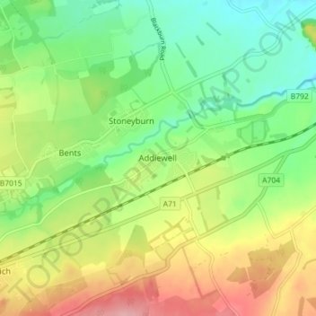
Name: Addiewell topographic map, elevation, terrain.
Location: Addiewell, West Lothian, Scotland, EH55 8HN, United Kingdom (55.82346 -3.64110 55.86346 -3.60110)
Average elevation: 643 ft
Minimum elevation: 472 ft
Maximum elevation: 889 ft
Other topographic maps
Click on a map to view its topography, its elevation and its terrain.
Linlithgow Palace and High Street Conservation Area
United Kingdom > Scotland > West Lothian > Linlithgow
Average elevation: 256 ft
Beecraigs Country Park
United Kingdom > Scotland > West Lothian > Linlithgow
Average elevation: 604 ft