
Make a donation
Gear up for your next adventure:
As an Amazon Associate, this site earns from qualifying purchases at no extra cost to you.
Busto Arsizio topographic map
Click on the map to display elevation.
Make a donation
Gear up for your next adventure:
As an Amazon Associate, this site earns from qualifying purchases at no extra cost to you.
Busto Arsizio
It was the road that connected Busto Arsizio to Arnate (today a district of Gallarate), corresponding to today's Via Gioacchino Rossini and its continuation of Via Gaetano Donizetti, which leads into Piazza Alessandro Manzoni, together with Via Quintino Sella, at the church of the Madonna in Prato. The name Garlasca is already found in 1399 in the Libro della Decima (Book of the Tithe) and also appears again in the Cadastre of 1857. In the topography of the late 19th century, it is found with the name of Galarasca local road, while from the beginning of the 20th century the current names of Via Gaetano Donizetti, for the first short stretch near the town centre, and Via Gioaccino Rossini appear.
Make a donation
Gear up for your next adventure:
As an Amazon Associate, this site earns from qualifying purchases at no extra cost to you.
About this map
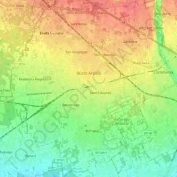
Name: Busto Arsizio topographic map, elevation, terrain.
Location: Busto Arsizio, Varese, Lombardy, 21052, Italy (45.56813 8.80479 45.64263 8.88197)
Average elevation: 722 ft
Minimum elevation: 623 ft
Maximum elevation: 823 ft
Make a donation
Gear up for your next adventure:
As an Amazon Associate, this site earns from qualifying purchases at no extra cost to you.
Other topographic maps
Click on a map to view its topography, its elevation and its terrain.
Parco archeologico di Castel Seprio
Italy > Lombardy > Varese > Castelseprio > Vico Seprio
Average elevation: 1,030 ft
Make a donation
Gear up for your next adventure:
As an Amazon Associate, this site earns from qualifying purchases at no extra cost to you.