
Thank you for supporting this site ❤️
Make a donation
Make a donation
Gear up for your next adventure:
As an Amazon Associate, this site earns from qualifying purchases at no extra cost to you.
Groppodalosio topographic map
Click on the map to display elevation.
Thank you for supporting this site ❤️
Make a donation
Make a donation
Gear up for your next adventure:
As an Amazon Associate, this site earns from qualifying purchases at no extra cost to you.
About this map
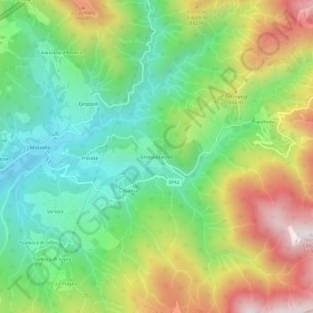
Name: Groppodalosio topographic map, elevation, terrain.
Location: Groppodalosio, Pontremoli, Massa-Carrara, Toscane, Italië (44.40300 9.92277 44.44300 9.96277)
Average elevation: 2,254 ft
Minimum elevation: 1,211 ft
Maximum elevation: 3,878 ft
Thank you for supporting this site ❤️
Make a donation
Make a donation
Gear up for your next adventure:
As an Amazon Associate, this site earns from qualifying purchases at no extra cost to you.