
Springfontein topographic map
Click on the map to display elevation.
About this map
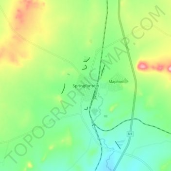
Name: Springfontein topographic map, elevation, terrain.
Average elevation: 5,016 ft
Minimum elevation: 4,813 ft
Maximum elevation: 5,407 ft
Other topographic maps
Click on a map to view its topography, its elevation and its terrain.
Gariep Dam
South Africa > Free State > Xhariep District Municipality > Kopanong Local Municipality
Average elevation: 4,321 ft
Tierpoort
South Africa > Free State > Xhariep District Municipality > Kopanong Local Municipality
Average elevation: 4,268 ft