Geolocate

Gaffney topographic map

Click on the map to display elevation.

About this map

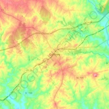
Name: Gaffney topographic map, elevation, terrain.

Location: Gaffney, Cherokee County, South Carolina, 29342, United States (35.03622 -81.71755 35.10685 -81.55761)

Average elevation: 719 ft

Minimum elevation: 518 ft

Maximum elevation: 958 ft

Cherokee County trails, hiking, mountain biking, running and outdoor activities

Other topographic maps

Click on a map to view its topography, its elevation and its terrain.

Macedonia

United States > South Carolina > Cherokee County

Average elevation: 820 ft

Maud

United States > South Carolina > Cherokee County

Average elevation: 915 ft

Maplewood

United States > South Carolina > Cherokee County

Average elevation: 689 ft

Gear up for your next adventure:

🥇GPS Hiking Watch - Multi‑sport GPS watch with navigation and trail tracking
🔋Solar Power Banks - Keep your GPS and phone charged in remote wilderness areas
🎒Hydration Pack - Hands‑free water reservoir for long hikes
📻Weather Alert Radios - Stay informed of storm risks while off-the-grid
🎒Trekking Poles - Sturdy poles for balance and stability on rough terrain

As an Amazon Associate, this site earns from qualifying purchases at no extra cost to you.